On the morning of April 9, near the col below Hyalite Peak in the Gallatin Range, a thin lens of cloud sat over the summit ridge while the valley below stayed clear. A party of four was halfway up the south slope. They turned around at 9:42 a.m. By noon the wind on the ridge was steady at fifty miles an hour and the lens had thickened into something stacked and unfriendly.
Cloud reading is not a substitute for a forecast. It is a substitute for nothing. It is the small, continuous correction a walker makes between the forecast they read at the trailhead and the weather that actually arrives.
Six cloud forms recur often enough on mountain ridges to be worth knowing by name. Most of the work is in distinguishing them from each other.
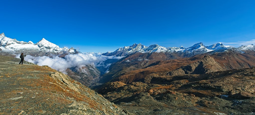
The first is the lenticular. It sits over or just downwind of a high point, lens-shaped, often stacked. It tells the walker that wind aloft is strong and stable enough to compress moisture into a standing wave. Lenticulars do not move. They form, persist, and dissolve in place. A single lenticular over a far peak is information. A field of them across a range is a warning.
The second is the cap cloud, sometimes called a pileus. It drapes a summit like a tight hat. Where the lenticular sits in the air column, the cap sits on the mountain itself. Both indicate strong upper-level flow. Neither, by itself, predicts a storm. Both predict wind.
The third is the cumulus humilis, the small fair-weather cumulus with a flat base and a soft top. In the early morning these are benign. By eleven a.m., if they have grown taller than they are wide, they have stopped being fair-weather clouds. That transition is the single most useful observation a ridgeline walker can make in summer.
The fourth is the towering cumulus. Its top is hard-edged and cauliflowered, often with a slight tilt downwind. It has not yet glaciated into a thunderstorm, but it will, often within forty minutes. A towering cumulus seen at ten in the morning means an afternoon storm is not a possibility but a schedule.
The fifth is the mature cumulonimbus, the anvil-topped thunderstorm cloud. By the time it is recognizable as such, the walker should already be off the ridge.
The sixth is the cirrus, the high, fibrous, ice-crystal cloud at the top of the troposphere. A single thin band of cirrus is unremarkable. A thickening, organizing field of cirrus that becomes cirrostratus over six to twelve hours is the leading edge of a warm front. In summer it can precede a weather change by a full day. In winter, less.
The order in which clouds arrive is more informative than any single cloud. The classic warm-front sequence is cirrus, then cirrostratus, then altostratus, then nimbostratus. The classic cold-front sequence is faster and rougher: a clear sky goes from scattered cumulus to towering cumulus to cumulonimbus in a few hours, sometimes with a wind shift and a sudden temperature drop.
A walker who can name what they are looking at can compare what they see to what the forecast promised. When the two disagree, the sky is the better authority. The forecast was issued at four in the morning from a desk in Salt Lake City. The cloud above the ridge is current.
There are local cloud forms that belong to specific ranges. In the Cascades, a low marine stratus deck rolls inland on summer mornings and clears by ten. In the Tetons, a banner cloud streams downwind from the Grand on windy days. In the Sierra, a thin haze of smoke now arrives in late July and stays through September; it is not a cloud, but it changes the light and disguises the formations that are.
Color matters less than shape, but it matters. A cumulus that has gone gray underneath is taller than it looks. A cumulus base that has gone ragged and dark is producing precipitation that has not yet reached the ground. A cirrus that has gone yellow is reflecting morning or evening sunlight from a long way off; it is neither good nor bad news.
The walker's most useful instrument is a watch. Note a cloud at ten. Look at it at ten thirty. Has it grown? Has it tilted? Has its base lowered? Three observations spaced fifteen minutes apart will tell a ridgewalker more than a dozen glances over a single hour.
It helps to know what the wind is doing aloft, separate from what it is doing on the ridge. The simplest tool is the direction the cloud tops move. If summit-level clouds are moving from the southwest while a surface wind comes from the east, two air masses are in contact, and the boundary between them will not stay where it is.
Many of the most consequential cloud observations are negative. A morning that should have brought up cumulus by ten and has not is a morning with unusually dry air, which often means unusually clear visibility and unusually low overnight temperatures. A summer afternoon with no convection at all in the high country is rarer than it sounds and worth noticing.
On the descent from Hyalite that April day, the party met a second group going up. The second group had not turned around. They mentioned the cloud over the summit and described it as pretty. They were experienced walkers. They were not stupid. They simply had not learned the name of what they were looking at, and so they could not yet hear what it was saying.
The Field Lantern recommends two small books for further reading: the Cloud Appreciation Society's The Cloudspotter's Guide for the names, and the American Alpine Club's Mountain Weather for the consequences. Neither is necessary. A walker who looks up often enough, with attention, will come to the same conclusions a little more slowly and remember them longer.
Cloud reading is a habit before it is a skill. It begins as a discipline of looking up at fixed intervals, naming what is overhead, and writing it down. Two seasons of this is enough to make a walker noticeably safer on a ridge. Five seasons is enough to make them useful to a less experienced partner.
Wendell Foss spent twenty-two years in the Forest Service before he started writing. He still keeps a paper cloud chart in the lid of his pack.